When lightning meets AI
When lightning meets AI
Isabell Stucke is on the trail of a very special weather phenomenon: upward lightning – bolts that shoot up from wind farms into the clouds and can cause significant damage. In this interview, the atmospheric scientist explains how she uses artificial intelligence (AI) and supercomputing to get to the bottom of lightning risks and why she’s convinced that the most exciting “aha” moments in research are still ahead of us.
Bettina Benesch
Isabell, what are the three words that come to your mind when you think of lightning?
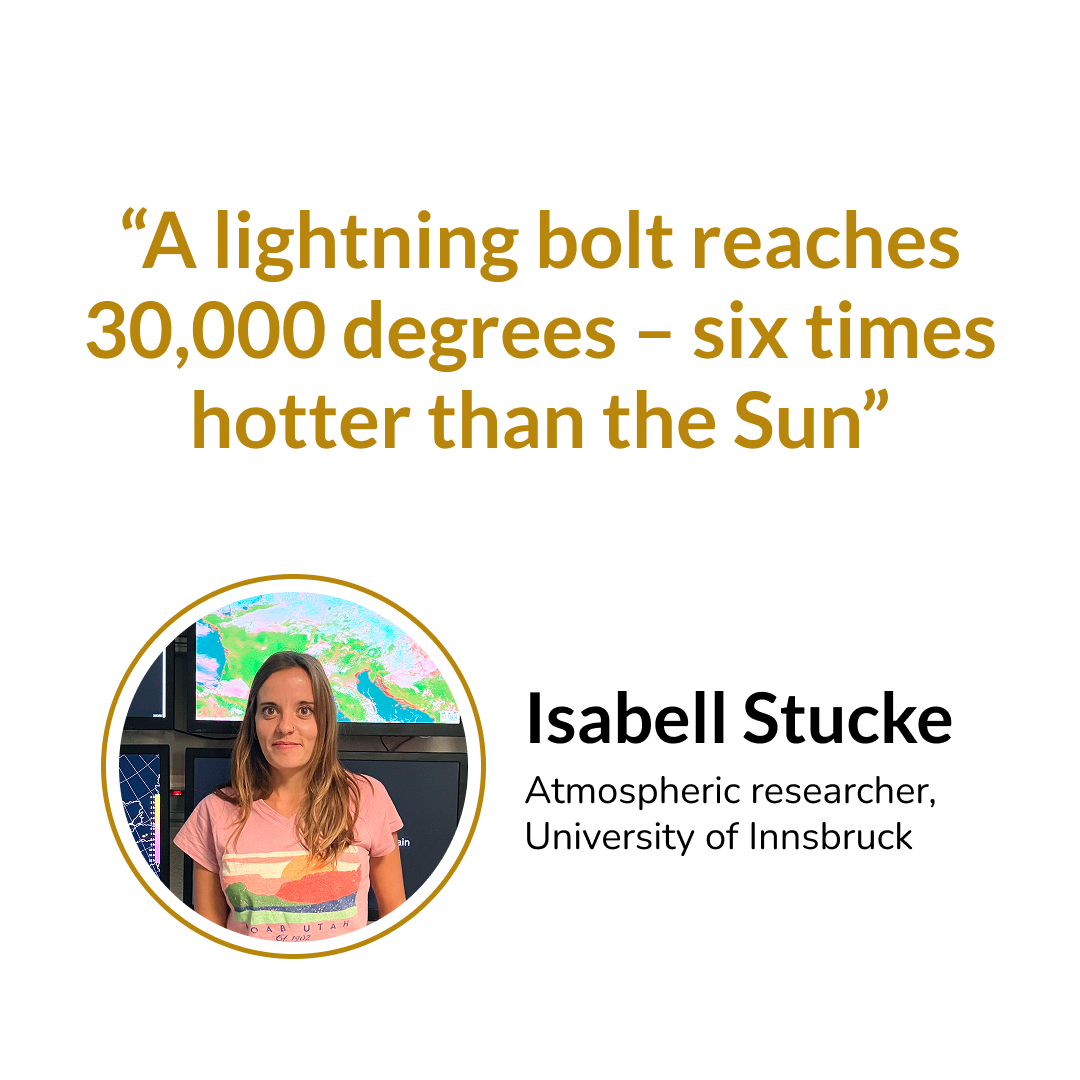
Isabell Stucke: Unpredictable and complex. Awe. And then extreme energy: a lightning bolt reaches 30,000 degrees – that’s about six times hotter than the surface of the Sun.
You’ve been researching winter thunderstorms and especially upward lightning for five years now. What do we currently know about this special kind of lightning?
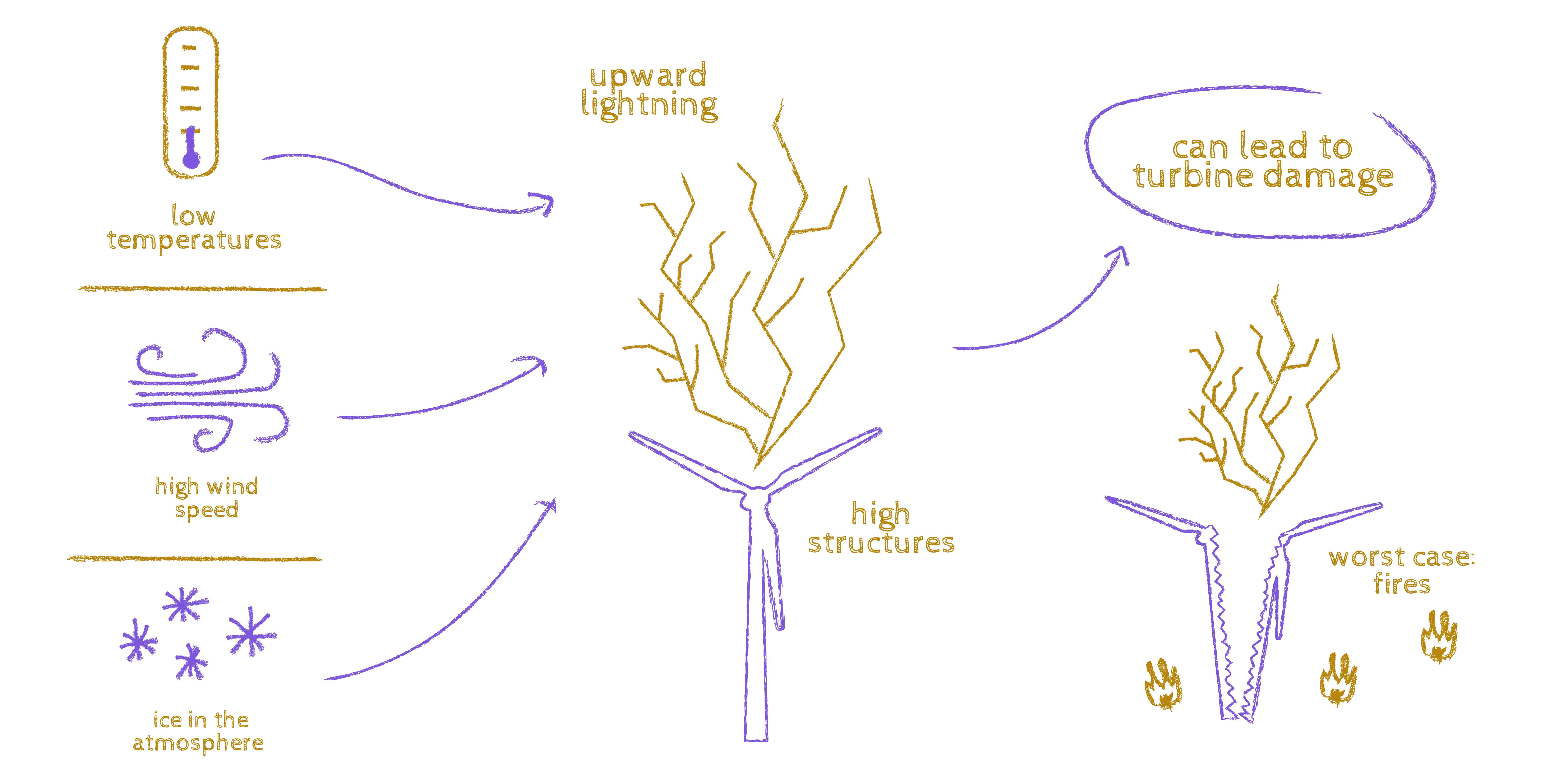
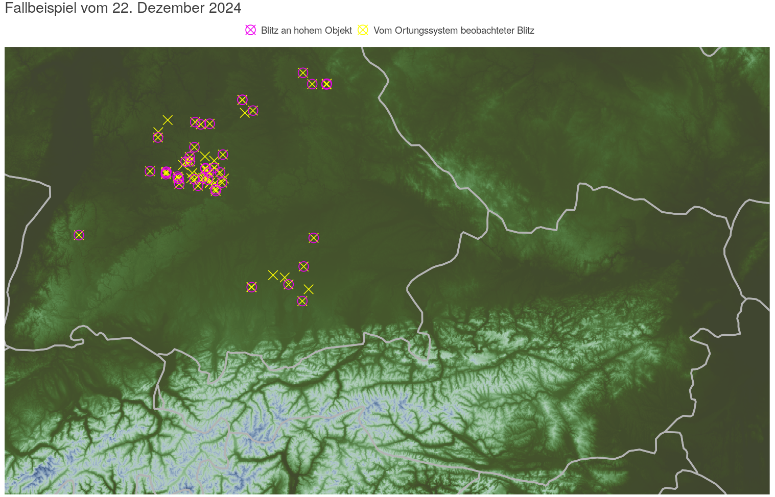
Isabell Stucke: Upward lightning isn’t triggered inside the cloud like normal lightning, but directly at tall structures such as wind turbines, and then rises from there. It can cause significant damage because it carries current for longer than ordinary lightning – which makes it a serious threat to wind turbines, for example.
For upward lightning to occur, you don’t just need an elevated point but also specific weather conditions. Unlike typical lightning, upward lightning mainly happens in winter or during transitional seasons, and under completely different circumstances than summer lightning. These are often cooler days with high wind speeds, when large air masses rise and higher ice content in the atmosphere can be measured. There are also geographical differences: upward lightning tends to occur north of the Alps – areas with dense infrastructure, such as in Germany, where very large wind farms are located.
What are the coolest facts about lightning?
Isabell Stucke: Cool fact number one: human-made infrastructure actively influences lightning activity. For instance, if a wind farm is built somewhere, there’s a very high chance that lightning activity will increase significantly compared to before. It’s now known that building wind farms can create lightning hotspots, especially in winter.
Twenty years ago, wind turbines were around 100 metres tall – today, they’re over 300 metres. And the taller the structure, the higher the likelihood that it won’t be struck by a downward lightning bolt, but will instead trigger an upward one itself.
“
Lightning also occurs in winter – and in this season, it’s especially energetic.
„
Cool fact number two: lightning also occurs in winter – and in this season, it’s especially energetic. Normally, conditions for thunderstorms are much more favourable in summer, because the sun provides much more energy. In winter, in theory, the prerequisites for lightning aren’t as good – and yet, it still happens.
Cool fact number three: using purely meteorological variables, we can predict quite accurately how high the risk of upward lightning is.
Cool fact number four: I’m currently comparing upward lightning strikes at a specific site – Mount Gaisberg in Salzburg – with those at three wind turbines on Japan’s west coast. These are two completely different climatic regions, and yet we find almost identical meteorological conditions for upward lightning in both.
Why is it important to understand lightning risks for wind farms at all?
Isabell Stucke: These days, lightning – especially upward lightning – is one of the most common causes of damage to wind turbines. As turbines get taller, upward lightning becomes more frequent. Lightning doesn’t just cause mechanical damage; due to its extreme thermal stress, it can also lead to melting of turbine components or even fires.
That sounds like an important topic for wind farms all over the world. How many people are researching upward lightning globally?
Isabell Stucke: There are only a few research groups worldwide working in this field – but not from such a detailed meteorological perspective as we do. That’s quite unique. At conferences where we present our research on upward lightning, I often hear people say, “Aha, I’ve never heard of that before.”
The awareness that upward lightning even exists has only been around for about a hundred years. In Austria and Europe, the unique characteristics of upward lightning only became known thanks to the Gaisberg measurement station, which has been operating since 2000.
What I find fascinating is that there are still things we know nothing about. We can research and research, and yet new areas will always emerge.
Isabell Stucke: Yes. Two things are decisive for us: on the one hand, progress in measurement technology, and on the other, advances in high-performance computing (HPC). Without HPC, it would be impossible to process such enormous datasets. It’s also becoming increasingly important to store and process data more efficiently – including through artificial intelligence. I believe we’re currently in an era of rapid progress, where we have countless new possibilities to explore topics like lightning physics.
“
Without high-performance computing, it would be impossible to process such enormous datasets. We’re in an era of rapid progress, with many opportunities to explore topics like lightning physics.
„
Which HPC system do you use for your calculations?
Isabell Stucke: The ASC (former VSC) in Vienna. We do have a small in-house mini supercomputer with four compute nodes, but that only allows me to run four jobs simultaneously. That’s fine for small datasets, but for the really large ones, I use the ASC.
Is there a particular success story or moment that stands out from your work or a project?
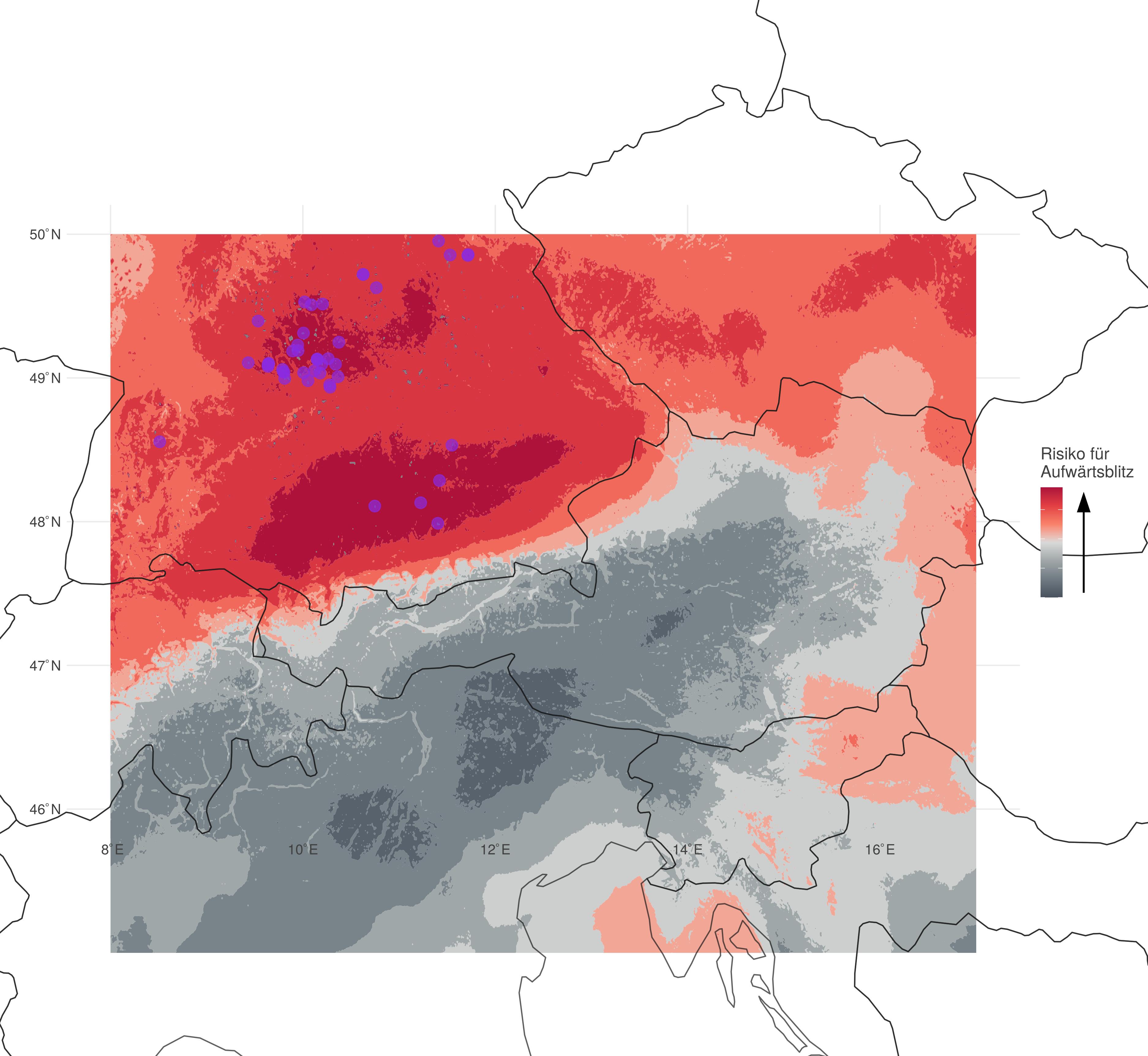
Isabell Stucke: I don’t think there’s just one single moment. For instance, when you’ve spent a whole week running simulations – after so much data preparation – and finally see a risk map that actually makes sense, that’s a real success. Or when you’ve made forecasts and identified a certain region as a high-risk area, and then the real data confirms that lightning actually occurred there – that’s a great feeling.
You also work with machine learning, a form of artificial intelligence. What’s your biggest challenge there?
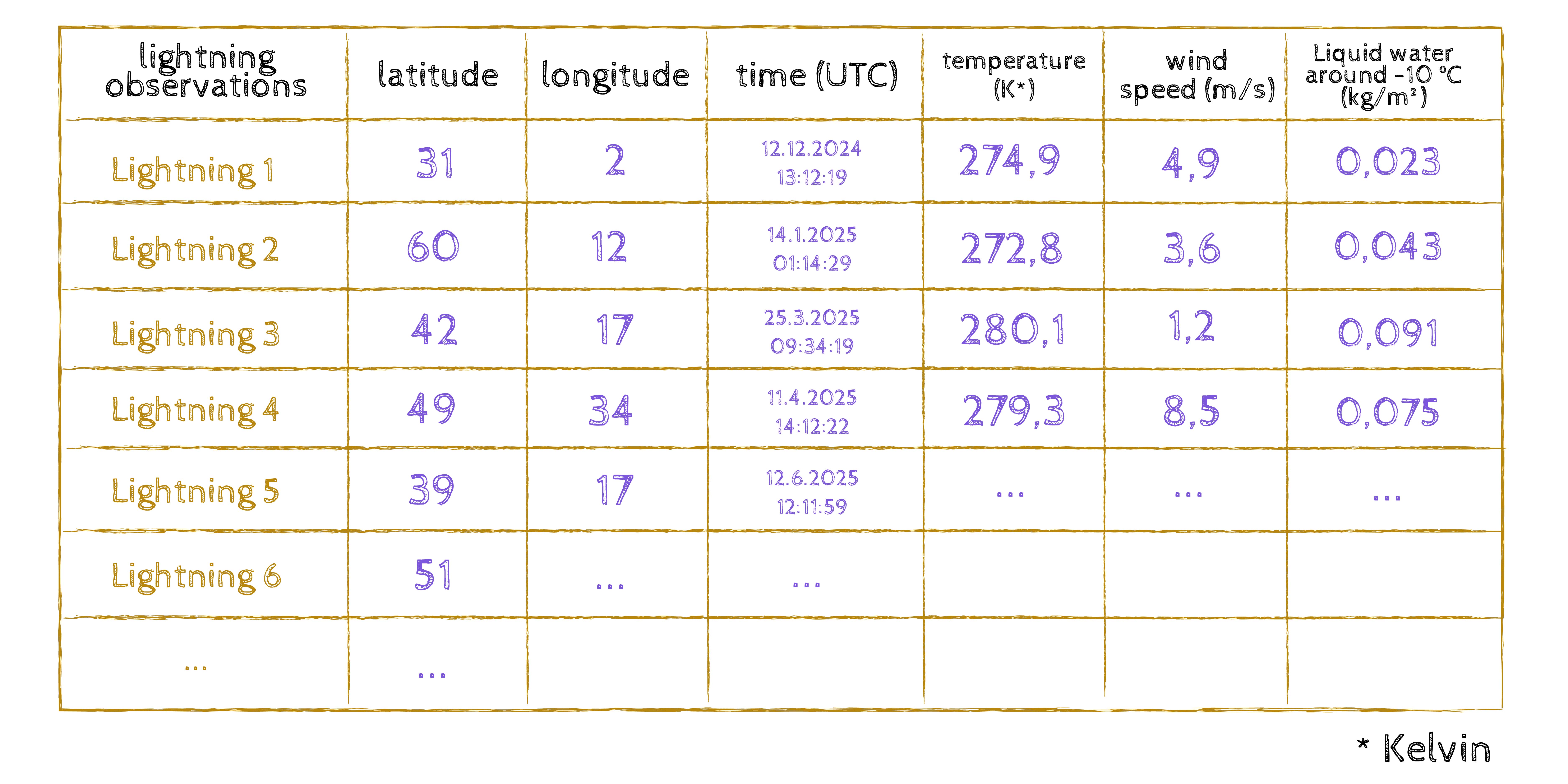
Isabell Stucke: My biggest challenge is preparing the data so that I can use it meaningfully. The lightning data itself isn’t the problem – I have time, location, and a few other metadata for each lightning strike.
Things get complex when I link each lightning strike to the meteorological conditions at the time. That makes the dataset huge, especially if I’m analysing lightning data for a whole year across Europe and want to know the precise atmospheric composition for every single event.
“
The biggest challenge is preparing the data in a way that allows me to use them meaningfully. The most complex work is when I link each lightning strike to its corresponding meteorological condition.
„
Can you give me an example of how you do that in practice?
Isabell Stucke: A dataset is like a table: the rows are my lightning observations. Let’s say I have a table with ten rows – one per lightning strike – and columns for latitude, longitude, and time of occurrence. That’s a dataset with dimensions three by ten. Then I add meteorological information such as temperature, wind speed, ice content, snow content, and water content of the air. These and many other parameters go into my calculations.
In the end, I end up with around 35 or 40 variables that I consider important, and I project them spatially and temporally onto every lightning strike. So that’s ten observations by 35 or 40 columns – and then scaled up to millions of lightning strikes. I feed that into my machine learning model, which classifies the complex relationships within the data. In the end, it tells me: “Okay, under these conditions, there’s an 80 percent probability that an upward lightning strike will occur.”
I came across your work on the Lightning Imager. The satellite-based lightning detection system has been delivering data since July 2024. What is special about this tool?
Isabell Stucke: To study upward lightning, I use both ground-based data – from lightning detection networks – and satellite data, specifically from the Lightning Imager. It’s an optical sensor mounted on a satellite consisting of four cameras. It monitors lightning activity from space and, unlike ground-based lightning networks, it doesn’t detect the electromagnetic waves from lightning but the optical signal reflected from the top of the cloud layer. Every millisecond, it captures an image of Europe, Africa, and the surrounding oceans. So the Lightning Imager covers an enormous area of the Earth’s surface. This allows us to continuously observe lightning activity – which is especially important over the oceans, where there are no ground-based detection networks.
But of course, it’s not perfect: because it’s an optical sensor, it can’t distinguish between cloud-to-cloud lightning and cloud-to-ground lightning (note: cloud-to-cloud lightning stays within the cloud, while cloud-to-ground lightning extends toward the Earth’s surface). And in cases of very thick cloud layers – several kilometres deep, as in summer thunderstorms – the Lightning Imager can’t detect lightning occurring at the very bottom of the cloud. This means its detection efficiency is generally a bit lower than that of ground-based sensors. That’s why it’s always advisable to combine satellite data with ground-based measurements.
And you do that, I assume?
Isabell Stucke: Yes. I then combine this data with a relatively large set of meteorological variables and use machine learning to understand why upward lightning occurs in the first place – and, in the next step, where and when it happens. For now, I’m investigating this only with ground-based data.
Why is that?
Isabell Stucke: The Lightning Imager has only been providing data since mid-2024, so we can’t yet use it meaningfully for statistical analysis. At the moment, we’re focusing on its detection efficiency – how well it can identify upward lightning. To do this, we compare the ground-based measurements with the Lightning Imager data.
“
The Lightning Imager has only been providing data since mid-2024, so we can’t yet work with them in a statistically meaningful way. For now, we’re first looking at how well it can detect upward lightning and comparing the ground-based measurements with the Lightning Imager data.
„
And ultimately, will you be able to predict lightning risk?
Isabell Stucke: Yes, based on the data, I can determine which regions have a higher average probability of lightning occurrence. Wind farms can then be equipped with better lightning protection accordingly.
What happens when things go wrong in your studies?
Isabell Stucke: I think experience helps. As a PhD student, you go through so many highs and lows. Sometimes, for weeks, absolutely nothing works the way you expected it to. And because I’ve been through those low phases so many times, I’ve learned that a high always follows. It sounds like a cliché, but it’s true. You just need patience and faith that things will turn around. And in the worst case, you just close your laptop and step outside.
“
Sometimes, for weeks on end, absolutely nothing works the way you thought it would. Because I’ve been through such low phases so many times, I know that a high always follows. You just need to be patient. And in the worst case, you simply close your laptop and head outside.
„
About
Isabell Stucke, PhD, studied Atmospheric and Cryospheric Sciences at the University of Innsbruck and is currently a postdoctoral researcher at the Department of Atmospheric and Cryospheric Sciences (ACINN). She has been researching winter thunderstorms since 2020, making her one of only a handful of scientists worldwide studying this topic in such detail.
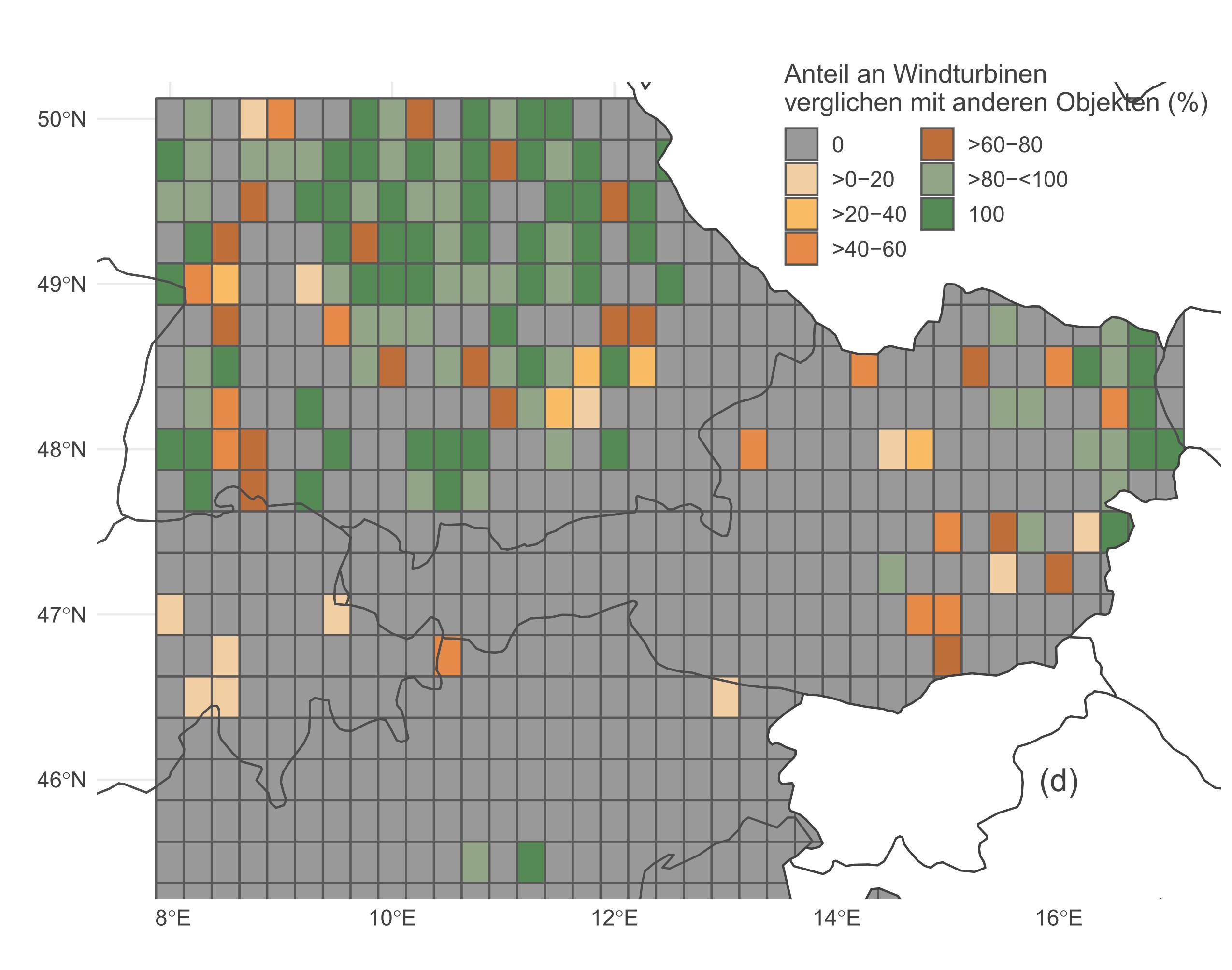
Isabell played a leading role in developing a risk map for upward lightning that covers Austria, parts of Germany, Switzerland, Italy, the Czech Republic, Hungary, Croatia, Slovenia and Slovakia. Since June 2024, as part of the project “Wind park lightning risk assessment with the Meteosat Third Generation Lightning Imager,” she has been assessing the risk of lightning strikes in Austrian wind turbines using the new optical sensor Lightning Imager and applying machine learning methods.